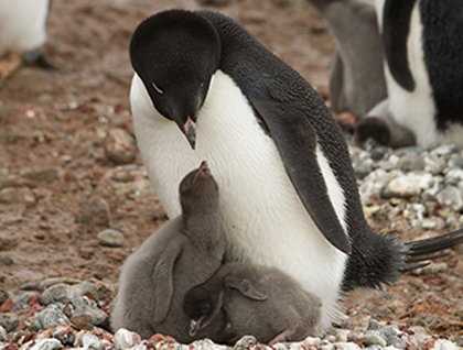

Early morning on the day of the summer solstice found us at Brown Bluff, 63 ° 28’ S, 56 ° 46’ W. It was -2°C, windless, the sea was calm, and a light dusting of snow was evident on the ships’s superstucture. An early shore landing was coordinated to visit the rookeries and glacier. Many Adelie penguins had chicks around two weeks old, and some were still incubating eggs. Gentoos also breed at Brown Bluff, but in smaller numbers compared to the Adelies. A one-mile hike took guests across a snow ridge and up a gully adjacent to a small glacier. A leopard seal lazed on a beached iceberg within sight of the pathway. Guests could pick out snow and pintado petrels wheeling overhead, and Wilson’s storm petrels that nest on precipitous ledges on the heights of the bluff. Kelp gulls, skuas and giant petrels were also frequent passers by. We were all aboard around 11 a.m. after a terrific morning ashore.
As we lunched the ship turned southward, through Fritjof Sound between the Tabarin Peninsula on our starboard side and Andersson Island. By mid-afternoon we were cruising through Erebus and Terror Gulf, so named for the two vessels commanded by Sir James Clark Ross during his extraordinary Antarctic explorations between 1840 and 1843. Prior to his Antarctic expedition, James Clark Ross had served through four full Arctic seasons on Royal Navy and privately funded expeditions. He proved his abilities as a physicist during one winter by taking an extensive set of magnetic records around the area of the north magnetic dip pole. He commanded this subsequent Royal Navy expedition to the Antarctic, which was one of so-called “scientific exploring,” where science and geography carried equal importance. Leaving Hobart in southern Australia he pushed South towards the region of his target, the south magnetic dip pole. His two specially reinforced ships, Erebus and Terror were able to traverse the protective band of floating pack ice and enter the polynia (an area of open water in an otherwise ice-bound seascape) and go further South than any human before. Following down the coastline he named the coastal ranges for his sponsors: the Royal Society Range, the Admiralty Range, and Prince Albert Range. His furthest south was marked by the massive ice shelf that he named “The Great Ice Barrier.” These ranges blocked his access to the region of the magnetic pole that he sought. His ships returned to Hobart over winter then made another summer foray southward to the same region then headed east to land in the Falkland Islands for the winter of 1842. In the summer of 1842-43 he took the ships south again to the Weddell Sea side of the Antarctic Peninsula, naming Erebus and Terror Gulf, through which we sailed today, and James Ross Island in honor of his uncle. James Clark Ross was truly one of the most significant and most successful polar explorers of the 19th century.
In spite of a light but constant snowfall, Patrick, the hotel manager (also serving as assistant expedition leader) delighted us with a beer and hotdog barbecue on the sun deck the mid-afternoon. Crabeater and weddell seals were seen on ice floes as we pushed southward and a vigilance was maintained in the hope of a sighting of an emperor penguin. At 64 degrees south we were stopped by a band of fast ice along which we coasted looking for wildlife.
At Recap time guests were invited to share a toast to Ernest Shackleton with a dram of the historic blend of scotch that was reproduced by the master blender at Whyte and Mackay, after analyzing and tasting samples of bottles from Shackleton’s Nimrod expedition of 1907-09.