We arrived early this morning at beautiful Ekenäs Archipelago National Park, which is composed of numerous rocky islets (skerries), as well as the surrounding waters, a short distance off the Finnish mainland. It was established in 1989 and covers an area of about 20 square miles (52 sq km). The park was formed to protect an important breeding area used by numerous sea birds, shore birds, and waterfowl. During our morning visit, we were fortunate to see many of the species dependent on the region, including mute swans, eiders, goosanders, greylag geese, a black-headed gull, great black-backed gulls, common gulls, common terns, common sandpipers, turnstones, oystercatchers, wheatears, and other birds whose identities were unconfirmed.
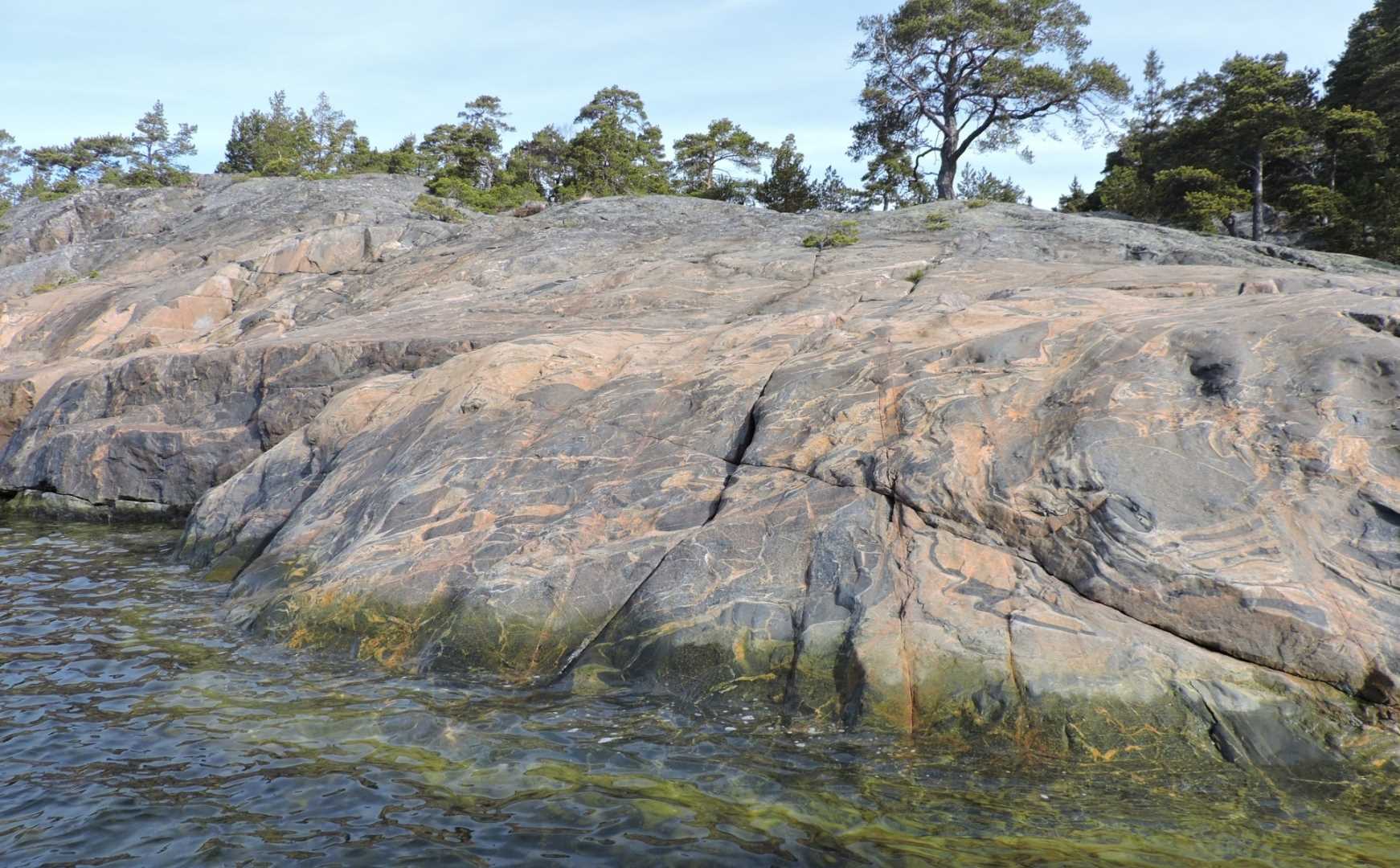
The geology in this park is fascinating. We landed to go exploring on the island known as Modermagan (which means “belly of the mother”). It is composed primarily of glacially-smoothed metamorphic gneiss, which in exposed areas shows amazing swirls of multicolored bands and sparkly dark splotches. Although the terrain is very uneven, it provided us with some excellent hiking through semi-open forest with mossy groundcover. Along the shoreline, the kayakers and Zodiac cruisers got great views of the exposed bedrock and also encountered erratic pink granitic boulders that had been deposited by ice movements long ago. The ice history of the place was very obvious in that the rocky islets exhibit smooth, rounded features and numerous parallel grooves and scratches, all of which were created by abrasive glacial ice and debris that was forced through the area more than ten thousand years ago.
Another fascinating aspect of the islands is they are rising in elevation because of a geological process known as isostatic rebound. A massive ice sheet covered all of Scandinavia and much of the Baltic area as recently as 11,000 years ago (the largest ice mass in this area actually occurred 20,000 years ago and was more than one mile or 1.6 km thick). The overbearing weight of ice cover depressed the land surface in this region about 6/10ths of a mile (one km) below its normal height. Since the ice melted, the land surface at this point has been rebounding…initially at the rate of almost 3 inches (7.5 cm) per year, but has slowed now to about 1/5th of an inch (4 mm) per year. Therefore, these islands in the Finnish Archipelago have changed dramatically through numerous generations of people living here.
It was remarkable to view the dense forest covering this rocky island. Obviously, the bedrock was scraped clean by glacial ice when it was exposed 9-10,000 years ago, so it had to reestablish a soil in which the plant life can thrive. This process takes a long time. Many people commented on the struggle the Scots pine trees must obviously endure to extend their roots into cracks and crevices in order to both gain essential nutrients and simply to hold onto the ground! Many of the trees appear stunted and almost Bonzai-like in the more exposed coastal areas, because of this struggle.
Those brave enough to taste the water were perhaps surprised to sense that it is almost completely fresh here. The salinity is only about 5 ppt in this region, compared to typical sea water, which is 35 ppt. Although the waters appeared very clean and clear around Ekenäs Archipelago National Park, when we got into open water to make our way into the Gulf of Finland and head for St. Petersburg, the sea water took on a more green-brown color, which may be indicative of an algal bloom…a serious problem inherent to the Baltic Sea nowadays.